 |
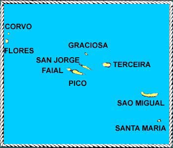 Azores, a group of nine islands in the eastern Atlantic, lie between 37 degrees and 40 degrees north latitude and between 25 degrees and 31 degrees west longitude. This puts them about 800 miles off the coast of Portugal, to whom the islands belong. Three hundred miles separate Flores, the westernmost island, from Santa Maria, which is the farthest east and south. They are 1,100 sailing miles from Falmouth, England and about 2,200 from Provincetown, Cape Cod. The islands were first found in the fourteenth century and then they were lost; Vasco da Gama rediscovered them in 1427. The islands lie south of the Gulf Stream and on the edge of the track of the North Atlantic gales. June, July and August are the prime months for yachtsmen in the Azores. The climate is mild and water temperature is in the 60's. |